Earth Watch Report - Earthquakes
…
| 4.1 | 96km SW of Firuzabad, Iran | 2013-05-04 00:09:54 | 28.327°N | 51.781°E | 10.0 |
…
M4.1 – 96km SW of Firuzabad, Iran 2013-05-04 00:09:54 UTC

Event Time
- 2013-05-04 00:09:54 UTC
- 2013-05-04 04:39:54 UTC+04:30 at epicenter
- 2013-05-03 19:09:54 UTC-05:00 system time
Location
28.327°N 51.781°E depth=10.0km (6.2mi)
Nearby Cities
- 96km (60mi) SW of Firuzabad, Iran
- 116km (72mi) SE of Bandar Bushehr, Iran
- 117km (73mi) SSE of Borazjan, Iran
- 141km (88mi) SW of Akbarabad, Iran
- 262km (163mi) NNE of Manama, Bahrain
…
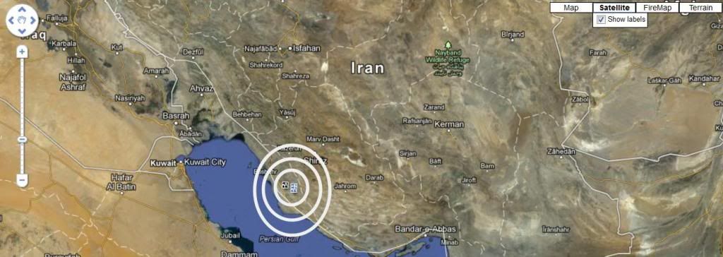
| 4.1 | 25km S of Shiraz, Iran | 2013-05-04 01:47:17 | 29.371°N | 52.557°E | 19.7 |
…
M4.1 – 25km S of Shiraz, Iran 2013-05-04 01:47:17 UTC

Event Time
- 2013-05-04 01:47:17 UTC
- 2013-05-04 06:17:17 UTC+04:30 at epicenter
- 2013-05-03 20:47:17 UTC-05:00 system time
Location
29.371°N 52.557°E depth=19.7km (12.2mi)
Nearby Cities
- 25km (16mi) S of Shiraz, Iran
- 25km (16mi) WNW of Akbarabad, Iran
- 58km (36mi) N of Firuzabad, Iran
- 91km (57mi) ESE of Kazerun, Iran
- 400km (249mi) NNE of Manama, Bahrain
…
| 4.2 | 99km SW of Firuzabad, Iran | 2013-05-04 04:13:22 | 28.152°N | 51.924°E | 10.0 |
…
M4.2 – 99km SW of Firuzabad, Iran 2013-05-04 04:13:22 UTC
Event Time
- 2013-05-04 04:13:22 UTC
- 2013-05-04 08:43:22 UTC+04:30 at epicenter
- 2013-05-03 23:13:22 UTC-05:00 system time
Location
28.152°N 51.924°E depth=10.0km (6.2mi)
Nearby Cities
- 99km (62mi) SW of Firuzabad, Iran
- 139km (86mi) SE of Bandar Bushehr, Iran
- 141km (88mi) SSE of Borazjan, Iran
- 147km (91mi) SW of Akbarabad, Iran
- 252km (157mi) NNE of Manama, Bahrain
…
Tectonic Summary
Seismotectonics of the Middle East and Vicinity
No fewer than four major tectonic plates (Arabia, Eurasia, India, and Africa) and one smaller tectonic block (Anatolia) are responsible for seismicity and tectonics in the Middle East and surrounding region. Geologic development of the region is a consequence of a number of first-order plate tectonic processes that include subduction, large-scale transform faulting, compressional mountain building and crustal extension.
Mountain building in northern Pakistan and Afghanistan is the result of compressional tectonics associated with collision of the India plate moving northwards at a rate of 40 mm/yr with respect to the Eurasia plate. Continental thickening of the northern and western edge of the India subcontinent has produced the highest mountains in the world, including the Himalayan, Karakoram, Pamir and Hindu Kush ranges. Earthquake activity and faulting found in this region, as well as adjacent parts of Afghanistan and India, are due to collisional plate tectonics.
Beneath the Pamir-Hindu Kush Mountains of northern Afghanistan, earthquakes occur to depths as great as 200 km as a result of remnant lithospheric subduction. Shallower crustal earthquakes in the Pamir-Hindu Mountains occur primarily along the Main Pamir Thrust and other active Quaternary faults, which accommodate much of the region’s crustal shortening. The western and eastern margins of the Main Pamir Thrust display a combination of thrust and strike-slip mechanisms.
Along the western margin of the Tibetan Plateau, in the vicinity of southeastern Afghanistan and western Pakistan, the India plate translates obliquely relative to the Eurasia plate, resulting in a complex fold-and-thrust belt known as the Sulaiman Range. Faulting in this region includes strike-slip, reverse-slip and oblique-slip motion and often results in shallow, destructive earthquakes. The relatively fast moving left-lateral, strike-slip Chaman Fault system in southeastern Afghanistan accommodates translational motion between the India and Eurasia plates. In 1505, a segment of the Chaman Fault system near Kabul, Afghanistan ruptured causing widespread destruction of Kabul and surrounding villages. In the same region, the more recent 30 May 1935, M7.6 Quetta, Pakistan earthquake, occurred within the Sulaiman Range, killing between 30,000 and 60,000 people.
…
******************************************************************************************************
Iran : 9 Earthquakes between 4.0 and 5.6 Magnitude registered April 10th, 2013
…
7.8 Magnitude Earthquake – 83km E of Khash, Iran
…
5.7 Magnitude Earthquake – 107km E of Khash, Iran
…
Iran : Seismic Activity Continues Three More EQ Ranging From 5.0 to 4.2 Mag On April 20th , 2013. A Total of 16 in six days.
…
Iran - 3 Earthquakes Ranging From 5.1 to 4.1 Magnitude May 01, 2013 . Total of 35 EQ’s in the last 21 days
Related articles
- Iran – 3 Earthquakes Ranging From 5.1 to 4.1 Magnitude May 01, 2013 . Total of 35 EQ’s in the last 21 days (familysurvivalprotocol.com)
- Iran : Seismic Activity Continues Three More EQ Ranging From 5.0 to 4.2 Mag On April 20th , 2013. A Total of 16 in six days. (familysurvivalprotocol.com)
- 5.7 Magnitude Earthquake – 107km E of Khash, Iran (familysurvivalprotocol.com)
- USGS: Earthquake Magnitude 6.3 – SE of Bandar Bushehr, Iran (sott.net)


